We explore the southeast coast of Norway and learn why it’s also called the “Norwegian Riviera”.
Mandal – Arendal (NOR)
“A gift from the harbour master!” says Ivar when he finds a little bag in the cockpit that contains fresh bread and jam. Following a good night’s sleep after our 3-day journey, we enjoy a sunny breakfast in our first Norwegian town, Mandal. We quickly learn that Mandal is not just easy to sail to, it’s also a picturesque town with a welcoming marina. As the westernmost harbor of the Norwegian southeast coast it is a good starting point to sail along this coast using the prevailing westerly winds. For the first time we see the typical red, yellow and white Norwegian houses among green trees and gray rocks. Just like a fairy tale. In the municipal harbour we get a spot assigned to the jetty after consultation with the charming harbour master. She speaks to us in Norwegian – a harbinger of how most Norwegians approach us – but quickly switches to English. In the village, everything is close together. There is a low-traffic area with squares and terraces. Next to the port is a new grocery store with more products and choices than other shops we would see on our trip, especially when it comes to vegetables.
Norwegian Hospitality
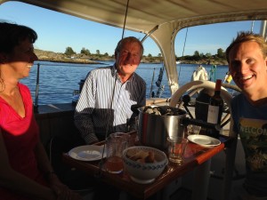
That same afternoon we get Norwegian neighbours. They are from Bergen and are on their way home. “What a beautiful ship,” Luci charms Leif and Marit. Soon we are engaged in deep conversation about the Netherlands, work, Norway, travel plans and anchor bays. They sit down to show us the best routes and places on the map. What appears as a labyrinth of rocks on the map, turns out to contain well-marked passages. This means we do not have to sail across the Skagerrak to the next place, but can uses ‘short cuts’, between small and larger islands. These turn out to be wonderful routes along beautiful islands where Norwegians have their holiday homes. We sometimes need to cross under power lines and bridges, so it is essential to know exactly how high your mast is. We measure it – to be absolutely sure – and hoist a tape measure at the spinnaker halyard. We measure (including VHF antenna) 18m above the water, so we can exactly pass under some bridges that are 19m high. There’s no need to take tides into account, there hardly are any around here.
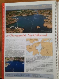
We choose our next destinations with the help of a spontaneous gift from our neighbors: the “Havneguiden Part 2” aka the Norwegian anchorage bible of the south coast, where numerous anchorages, natural harbors and cities are described along the south coast in detail and illustrated with photographs and drawings. It’s hard to choose: they are look breathtaking, so we are looking forward to our upcoming voyage of discovery.
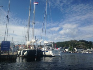
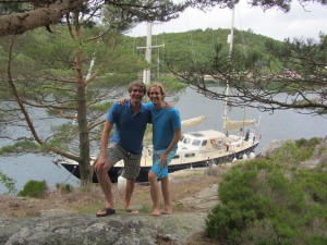
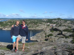
Beautiful Mandal, Lucipara2 moored next to “Puffin” – Leif & Marit’s boat
“Havneguiden 2” the anchorage bible that Leif & Marit gave us. Priceless!
When in Norway…
At our first anchorage, at Skogsøy, we are sheltered between islands. There is little swing space, so when the wind turns we add an anchor on our stern and connect Luci to the shore with two lines. A lot of work, and we soon see that the Norwegians are much more efficient: mooring alongside a rock. The rocks go steeply down in many places, leaving enough depth for Luci. As soon as a place becomes available we try it, and we discover metal rings that are tightened to the rock for easy fastening. The Norwegians often moore with the bow to the rock, combined with a stern anchor. We use the rocks preferably as long scaffold, especially if there is enough room. The “Havneguiden” shows on the drawing where such rings exist, so we soon select our anchorages accordingly.
Sailing Northeast
The prevailing westerly winds enable us to sail with only the genua, which means that we can easily manoeuvre between rocks and shorelines from island to island, guided by markers in the form of paint, sticks or miniature lighthouses. It takes us a while to get used to spotting and following these markers, so we are happy that we also have the iPad to assist with the navigation. At times the passages are so narrow, that only one boat can pass at a time. This is particularly the case on the spectacular stretch between Gamle Hellesund (East of Kristiansand) and Lillesand. It puts our steering skills to the test, so we’re thankful that we can follow a much wider catamaran – if they can pass, so can we. The scenery that unfolds after each corner has us gasping and going from one “wow” to the next: natural bays surrounded by trees and colored wooden houses and boat houses, children frolicking around in gardens and on small boats. We immediately understand why this part of Norway is such a popular domestic holiday destination for Norwegians and also nicknamed the “Norwegian Riviera”.
The most beautiful place we find is Olavssundet (Ny Hellesund) – between Mandal and Kristiansand. This natural bay offers everything that makes Norway special. Islands where you can walk around, 360 degree views, a water-rich environment to explore endlessly and even a restaurant where you can come by foot or dinghy.
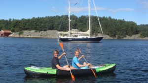
We have an inflatable kayak and take every opportunity to explore the area from our anchor spots. We paddle around islands for many kilometers, up and down rivers and fjords. Sometimes we need to carry the kayak and walk with it to the next fjord. It takes us to shallow areas, under low bridges and cables where we can’t go with Luci. We thus find ourselves in the midst of nature which makes Norway so special. Also, we harvest mussels from cliffs using the kayak (delicious!).
Although this coast is very popular with Norwegians and everywhere are holiday homes, it is never crowded. The thousands of large and small islands provide an immense coastline, countless coves and beautiful scenery. We make short day trips – why would you sail 60 miles when the next wonderful destination is only 20 miles away? We take the time to explore the area and alternate between anchoring in nature with mooring in towns. Besides Mandal we especially liked Grimstad. The port is spacious and has good facilities (WiFi), there are nice shops and restaurants and we made wonderful hikes in the area.
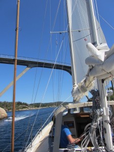
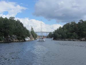
Our first inshore trip: we fit exactly underneath the 19m high bridge
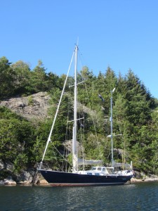
Our first anchorage, at the beautiful island of Skogsøy
The Norwegian way: mooring alongside a cliff
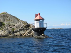
The inshore routes are very clearly guided by markers in various shapes and colours
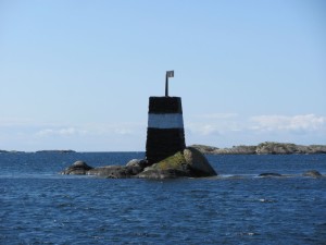
Typical Norwegian miniature lighthouses, at night they indicate sectors with different colours of light
Following a catamaran in the narrow passages between Kristiansand and Lillesand
Our favorite anchorage: Olavssundet (Ny Hellesund) – between Mandal and Kristiansand
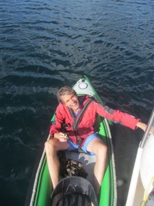
Walking the kayak to the next fjord…
View on Grimstad
Meeting New Friends
Wherever we come, Luci and our Dutch flag act as icebreakers with the locals. People start conversations with us to ask about the boat or our journey from the Netherlands. They often know a Dutch person or have been to the Netherlands. Without exception the Norwegians we meet that way are very friendly, interested and hospitable. Our most memorable encounter is with Marianne and Ragnar. We briefly speak to them at the gas station in Grimstad, where they assist Ivar with the Norwegian instructions on the pump. After filling up we sail off to the next destination that we picked from the guidebook.
Some three hours later and 15 miles further we’re safely anchored in another stunning bay close to the open sea, but protected from it by small islands with grazing sheep. While we finish a late lunch there’s a knock on the boat. At first we ignore it because we don’t think it’s someone actually knocking on the boat – we’re in the middle of a bay, after all. Another knock follows, so Floris pops out his head to see what’s going on. There is Ragnar in a dinghy, explaining that he and Marianne live here. What an incredible coincidence! He points to a house at the end of the bay and explains how he had seen the boat from his window and could not believe he was seeing the same boat as in Grimstad.
Do You Want to See My Museum?
Ragnar invites us to see his museum of telecommunication, so a few moments later we’re in his dinghy, looking back at Luci. His collection of marine telecommunication devices, radios, telegraphs, even cell phones is very impressive. And everything works. He still uses some of them, for example to speak to polar expeditions or other amateur radio operators. But Ragnar is more than a collector, he has also led an interesting life and is a very active member of the community. The same is true for his wife Marianne, as we hear over local beers in their living room, overlooking the bay and with a great view of Luci. Marianne is a pediatrician who has also worked in townships in South Africa. Anxious to get to know them better, we invite them for dinner on the boat the next day. We continue our conversation there and then, after a kayak tour up the river and harvesting mussels for the starter. The biggest (and most delicious) mussels grow about one meter under the surface, out of reach of the seagulls and just close enough for us to reach from the kayak. We go from rock to rock by kayak to scavenge the area around the boat for the best mussels until we have sufficient for our guests and us. Having never done this themselves, Ragnar and Marianne have to overcome some worries about possible mussel-diseases, but they’re sold after the first taste. We spend a lovely evening discussing everything from our project, politics, food, Norwegian winters, electric cars and the (absence of) police. We think at that point we both knew that we wanted to see more of Scandinavia and a possible reunion with them next year only adds to the appeal.