We want to sail north to Canada, Greenland and Iceland. How will our plan to sail back to Europe via the Viking Route unfold?

The video is in the making. 

Somesville (USA) – Reykjavik (ISL)

We’re at anchor in a deep inlet in Halifax, Canada. On our port side is the local yacht club, where we can get a warm shower. On our starboard side sit stately homes with gardens that reach down to the sea. Each property has its own dock with small boats or paddleboards patiently waiting for their owners to take them around the inlet. It’s a peaceful scene, in sync with our experience in Canada so far. Only last week we departed from Somesville, Maine, and a pleasant two-day trip later we arrived in picturesque Lunenburg. The check-in was easy and quick: the immigration/customs officers came to the boat, had a short chat and handed us our cruising license. The town was pretty and would have merited a longer sojourn, but the capital of Novia Scotia beckoned. Our friends Annemiek and Niclas will meet us there, so we want to make sure we’re there when they arrive.

Shortly after dropping the hook in the calm waters of the inlet, Floris checks our e-mails for news from our friends. Instead, he finds a message from an unknown sender: “What a remarkable trip you guys are making! Are you coming to have a drink with us?” Floris reads from Stephen’s email. He writes that he spotted Luci from his living room across the water. “Yes, please!” we reply, and later that afternoon we paddle to their dock and walk up the garden. Stephen and his wife Janet greet us warmly and usher us inside, where a platter of mouthwatering bites is waiting for us. They offer us local beers and Canadian wine and within minutes, it feels as if we’ve known them for years.

“Why do you want to go to the far north?” Stephen asks after we have told him our plans.
“In Patagonia, we experienced how beautiful sailing at high latitudes can be,” Ivar answers. “The Vikings also sailed the northern route and established settlements in Newfoundland, Greenland, and Iceland. We want to sail in their wake.”

The confidence with which we share our sailing plans conceals an underlying uncertainty. The area is notorious for icebergs and stormy weather.
“The Azores is our plan B,” Floris adds, prudently.
“We will follow you, online! And feel free to use our jetty while you’re here. Also, would you like to take a shower? And do the laundry?” Janet asks.
“It’s as if you can read my mind,” Floris beams.

Hospitality and wilderness in Nova Scotia

For almost a week, we use Janet and Stephen’s jetty as a base to stock up on provisions and explore the city. In the history museum, they make no secret that the worldview of the colonial British, based on exploiting nature, clashed with that of the region’s first inhabitants, the Mi’kmaq. The Mi’kmaq believed that human and natural worlds are one and the same. Consequently, people should take only what is necessary from nature and preserve it for future generations. “Their worldview reminds me of the Māori and the Aboriginals. It’s remarkable how indigenous peoples across different continents treated nature with respect based on the same principles,” says Floris.

“This was the only way to survive for thousands of years, until colonialism began,” responds Ivar.
“How do we ensure these ideas are applied on a larger scale?”
“Self-preservation. I hope more people will realize that our survival largely depends on nature’s wellbeing and that we must therefore act according to indigenous wisdom,” Ivar concludes.

Our lovely neighbours’ hospitality reaches a new high when they offer our friends Annemiek and Niclas a boat ride to Luci following their arrival in town. The next morning we wave Janet and Stephen goodbye and prepare ourselves and our new crew for departure. A minke whale swims curiously alongside us as we leave Halifax behind. In day trips, we hop along Nova Scotia’s coast. The landscape is hilly, covered with conifers, and remarkably wild. In one of the anchor bays, an iconic American bald eagle keeps a vigilant eye on our sailboat from a tall pine tree, as we anchor in its territory. Through the lock at the village of St. Peter, we enter the sheltered waters of Bras d’Or Lake. We sail on flat water, explore picturesque villages, and wander through maple forests.

Newfoundland: the Pinnacle of Hospitality

When the weather forecast promises favorable winds for overnight sailing, we cross to Newfoundland. On the pristine south coast, we drop anchor in Culotte Cove. The nautical chart is completely inaccurate here, but fortunately the bay is wide and deep enough to keep the rocks at a distance. Dark green forests, steep hills, and grey rocks compete for our attention. Suddenly, we notice movement on the shore.
“A caribou,” Floris whispers excitedly. As quietly as possible, we kayak to the beach where the magnificent animal calmly grazes. Only when we’re nearly there does it calmly trot away. Thrilled, we pull our kayak ashore and follow the paths that caribou have carved through the wilderness. We climb higher and higher until we reach a rock with panoramic views. Nothing but natural beauty surrounds us. We feel insignificant. As far as we can see, there are green hills, grey rocks, and forests. After exerting ourselves in the summer heat, it’s time to seek refreshment in a mountain lake. We bathe in the cold but wonderfully sweet water until swarms of bloodthirsty midges attempt to devour us alive. Thanks to the anti-mosquito spray that Floris packed in his backpack, the itching remains somewhat bearable afterward.

Further east, we sail into the deep fjord of La Hune Bay. The high, smooth mountain walls testify to the unimaginable primeval forces that glaciers unleashed here long ago. The area is so remote that the nearby hamlet of Francois can only be reached by boat. Colorful houses cluster around a bay flanked by steep rock faces on three sides. Quad bikes are parked beside the houses, along with snowmobiles—evidence that this place is far less hospitable for much of the year.

“I think it’s beautiful here,” says Floris as we gaze down at the bay and village from a viewpoint. “It’s very remote and nothing happens here.”
“It’s not Amsterdam, no.”
With this, Ivar voices something that’s been on our minds for some time. Despite the many remarkable places we’ve visited over the years, nowhere felt as much like home as Amsterdam. We miss the cycling culture, excellent public facilities, cinemas, theatres, festivals, and especially the warmth of family and friends. As we draw closer to home, our thoughts increasingly drift to life after the journey.
“First we have to cross the Atlantic Ocean, again.”
“Minor detail.”

In a single day, we sail to Fortune harbour. We’ve barely moored when our neighbours invite us for drinks with delicious, fresh scallops. They offer extensive advice about their island, including what to do if we encounter moose (“Run!”) and the best places to spot puffins. Other neighbours, also local Newfoundlanders, offer to drive us to the nearest car rental place, almost an hour away. We can’t help but be amazed by their hospitality.

The weather forecast has thwarted our plan to drop Annemiek and Niclas off at St John, so we need to drive there instead. On the plus side, the change of plans allows us to see Newfoundland’s interior. Together with our friends, we hike in national parks, admire puffins, spot whales from the shore, and visit the island’s capital St John. Time flies and soon it’s time for goodbye hugs. We know they’ll be waiting at the dock when we return to Amsterdam in a few months, which lifts our spirits.

With only the two of us again, we soon set sail again (after car rental lady drove us 50 minutes back to Luci!). We follow the coastline north, sail past St John and reach Catalina. We can moor at a wooden dock, for free. Fishermen offer us fresh cod fillets, and someone else brings firewood after he sees Ivar sawing logs into small pieces for our stove. When we walk to a gas station with empty jerry cans, a pickup truck stops. “I saw you guys walking past my house, so I thought: I’ll get in my truck and help you.” Gratefully, we climb in. After the gas station, he drops us off at the dock. We’re almost speechless. We’ve encountered friendly, hospitable people almost everywhere, but the Newfoundlanders truly surpass them all.

Ice, Ice Baby

Daily we study Greenland’s weather and ice conditions. Only during the brief summer season conditions are relatively favourable for the crossing. It’s almost July, and we want to return to the North Sea by late August, before autumn storms ravage the North Atlantic. However, there’s currently an unusually large amount of ice off Greenland’s southwest coast, blocking the ports there. The climate crisis is certainly contributing—Greenland’s land ice is decreasing. The meltwater seeps down and reduces friction between rock and glacier ice. Some climate scientists compare this lubricating effect to WD40. This causes glaciers to move faster, sending more icebergs into the sea than before.

The capital Nuuk, located further north, remains ice-free. The drawback: it adds over 100 nautical miles to our crossing. With storm depressions following each other in quick succession, we prefer to keep the journey as short as possible. Moreover, we’d still need to head south from Nuuk to continue the Viking route. While evaluating our options, we receive disturbing news about a Norwegian sailing yacht stuck in the ice, exactly where we intended to go in southern Greenland. The incident emphasizes that we shouldn’t underestimate this area.

“We’ll only go when the ice charts show that hardly any ice remains,” Ivar concludes. “If that doesn’t happen soon, it’s Plan B.”
We don’t remain stationary but sail further along Newfoundland’s north coast. This gradually shortens our potential crossing to Greenland. En route, we’re treated to a magnificent animal display. The waters teem with foraging whales and seabirds. Gigantic, lumbering humpback whales surface ahead of our boat on both sides. Gannets and petrels demonstrate their diving and swimming prowess. Our favourites are the comical puffins, distinctive with their bright orange beaks, stocky appearance, and rapid wing movements. All their activity is focused on catching capelin, small, silvery fish that school in these waters.

Whenever anchored or docked, we study the latest ice charts. “Still too much ice,” Ivar sighs.
Keeping Greenland as an option, we cross to Labrador, slightly further north. At night, we pass Newfoundland’s northernmost point, where Vikings once established a settlement.
“I would have liked to explore it here,” Floris laments. He understands we can’t stop due to approaching headwinds, but even after all these years, he still feels frustrated when weather denies him a destination. During his night watch, he regularly checks the radar for icebergs. According to our pre-departure ice chart, several float in this area. Fortunately, the screen shows nothing. Only as we approach the hamlet of St. Lewis do we encounter a grounded specimen. The white colossus serves as a warning—we’re unmistakably in waters with merciless, mobile dangers.

From here, the crossing to southwest Greenland is just under 600 nautical miles. It won’t get any shorter. This must be our launching point, either for Greenland or the Azores. The latest ice charts finally bring good news: southern Greenland ports are accessible. But what about the weather? We check wind forecasts several times a day. On two occasions, we’re poised to depart but our intended weather windows abruptly close when sudden, rapidly deepening depressions appear in the forecast. We postpone our final decision until early morning on July 22. It’s now or never. Otherwise, we’ll set course for the Azores. We anxiously study various weather models. “No storms for five days, Greenland is possible!” Ivar cheers. Finally, in the wake of a receding storm depression, we cast off and set course for Nanortalik in southwest Greenland.

Iceberg! Right Ahead!

The sea is rough initially, but after a day the waves subside as the wind decreases. Suddenly, straight ahead, we spot something blindingly white: an iceberg! The colossus is miles away and must therefore be enormous. Breathlessly, we examine its irregular shapes and myriad shades of white and blue up close. We now understand why the pilot books recommend passing icebergs upwind: countless small ice chunks float on the lee side. These fragments won’t appear on radar but can still be large enough to sink a sailing yacht. We maintain a vigilant watch throughout the day, switching on the radar at night. Double layers of thermal clothing, hats, and gloves should keep us warm, but the temperature drops steadily as we approach Greenland.

More crucial is avoiding any storm depression overtaking us. The forecast predicts one, but we should stay ahead of it. We receive a message from another sailboat reporting an iceberg about 30 nautical miles off Greenland’s coast, which matches the ice chart. Coincidentally, our timing is perfect: we reach the beginning of Greenland’s ice zone precisely in the early morning of the fifth day. According to the latest ice map, the icebergs should be apart widely enough to navigate between them. Then suddenly, the fog thickens.
“What now?”
“You keep lookout, I’ll activate the radar,” Ivar decides.

For hours, we slalom around icebergs, which appear as purple dots on the radar screen. When we’re just five nautical miles from shore, the fog dissipates as quickly as it appeared. Now we’re face-to-face with dozens of icebergs floating in deep blue water. Behind them loom brown-green mountains with snow-capped peaks. We’re speechless before such magnificent natural beauty. After securing Luci to a quay in Nanortalik, Ivar exhales a deep sigh of relief. “We sailed to Greenland on our own keel!”

Storm and Fjords

Soon after our arrival we explore the town. Houses made of cement, corrugated iron, and wood are simple but vibrantly colored: green, blue, and red. Between them lie rocks and patches of grass where flowers grow. Murals of whales and birds brighten the scene. A hotel offers wifi, we shop at a Danish supermarket, and clear in with friendly Danish police officers. Nanortalik means “place of the polar bears” in Greenlandic. Is it safe to walk without a gun, we wonder? The police officer reassures us that there haven’t been large ice floes recently, so according to him, no polar bears either. Still, as we reach the limits of town and venture into the countryside, we remain somewhat vigilant. An encounter with a polar bear can be fatal. We climb a nearby mountain and marvel at views of fjords, mountains, and the last ice floes. No polar bears anywhere, fortunately. The next morning, the wind intensifies considerably. The storm we spotted in the forecast is approaching. For almost two days, winds blow up to 60 knots. We’re immensely grateful to be sheltered at a sturdy quay.

As soon as the wind subsides, we sail through fjords toward the east coast. We navigate past icebergs large and small to Ikigait bay, where we drop anchor. We paddle ashore and discover the ruins of a Viking structure.
“To think that a settlement existed here over a thousand years ago,” Floris remarks. “Incredible, especially considering the Vikings had no radar, weather reports, or maps,” Ivar responds in admiration.

Via the tiny village of Aappilattoq, we reach the famous Prins Christians Sund, a spectacular fjord fed by several glaciers and waterfalls. We gaze at mountain peaks, ice masses, and rock faces throughout the day. The sun shines in a brilliant blue sky. The fjord ends on the east coast, which is an ideal jump-off point for our next leg to Iceland.

Land of Volcanos and Ice

We cast off once the storm’s remnants move eastward. Unfortunately, we can’t keep pace with the wind, so we clock more engine hours than we like during the first days. When more wind arrives, it’s almost straight against us. For days, we tack upwind, sailing into substantial waves. Our progress is agonizingly slow. Only after seven days we spot snow-capped mountains in the distance. The final tacks to Reykjavik seem to take forever but when we finally stand under the yacht club’s shower that evening, we’re relieved that we didn’t encounter any storms during this crossing, the longest of the Viking route. The warm, slightly sulfurous water leaves our skins baby-soft. We’re clearly in the land of volcanoes.

Letter to the Future

We explore Reykjavik on foot before visiting the Perlan museum. Stunning films and interactive displays provide an excellent overview of Iceland’s volcanoes, landscapes, and nature. We learn about the Ok glacier – which is anything but O.K., as it has the dubious honour of being the first Icelandic glacier to disappear due to the climate crisis. A bronze plaque titled “A letter to the future” commemorates this event:

Ok is the first Icelandic glacier to lose its status as a glacier.

In the next 200 years all our glaciers are expected to follow the same path.

This monument is to acknowledge that we know

what is happening and what needs to be done.

Only you will know if we did it.

August 2019

415 ppm CO2

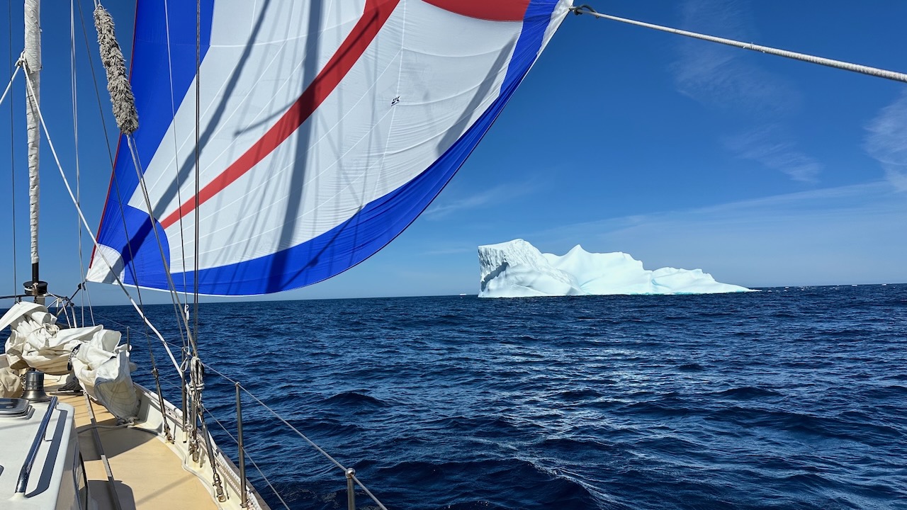
We decide to go see it for ourselves. After driving through otherworldly landscapes characterized by red rocks and barren hills, we park our rental car. We climb nearly five kilometers over rocky terrain. Once at the top, we see only meager remnants of ice. Since the ice no longer moves, the Ok glacier has been declared dead. Up there on that mountain, amid Iceland’s vast primeval landscape, we grasp its historical significance. Through human actions, Iceland’s ice could potentially disappear entirely. Like the melting glacier in Patagonia, this place reminds us how far-reaching the consequences of human behavior are. Through the boundless sea that connects us all, the entire world will be affected by additional sea level rise from Iceland’s meltwater.

Heading Home

The dead glacier makes us think about the many inspiring sustainable solutions we’ve encountered along our journey. Nearly all contribute to curbing the climate crisis. “If only these were applied on a large scale,” Ivar contemplates. We both feel a strong desire to share these solutions with as many people as possible. That will be our goal when we return home.

But how do we get there? It’s now mid-August, and the first autumn storm approaches.

“If we hurry, we can reach the Faroe Islands before the storm hits,” Ivar calculates. Floris suppresses the thought of exploring Iceland more extensively and agrees. We use the rental car another day to get as many “aaaah’s” and “ooooh’s” as possible in – we refer you to the pictures – before we hoist the sails and set course for the Faroe Islands, almost 500 nautical miles eastward. “A destination for Vikings who were too seasick to sail all the way to Iceland,” Floris reads from the pilot book with a smile.